
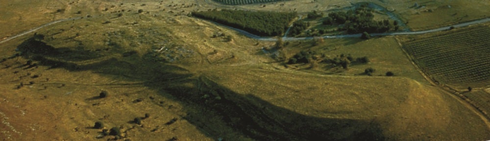
Our 1997 team consisted of seven members–Professors Herbert and Berlin, as well as five graduate students, three from the University of Michigan (Geoff Compton, Carla Goodnoh, and Chris Monroe) and two from the University of Minnesota (Jarrett Lobell and Jacob Dorer). Surprisingly for a site of its importance, no accurate topographical map had ever been made of Tel Kedesh, and this was one of the major goals of our 1997 season. Using the Kelsey’s Sokkia electronic surveying station, we were able, under Geoff Compton’s guidance, to establish a grid system and complete a topographic map of the lower tel in a little under two weeks.

1997 Team
Meanwhile other members of the team cleared the six-foot thistles off selected grid sections and collected all objects visible on the surface of these areas. Based on field analysis of the materials collected and on topographical considerations, we placed a small probe trench at the western edge of the lower tel and another in the center south. We excavated these probes for nine days, then processed the finds for four days. Both probes revealed stone walls and floors at depths varying from .5 to 1.3 m below modern surface. The pottery associated with the floors dates to the mid-second century BCE. No architecture later than Hellenistic was present in either probe trench. In fact, much of the lower tel appears to have been unoccupied after the Hellenistic period. The material from the southern probe was particularly interesting, with intact pots, loom weights, and other domestic artifacts left on the Hellenistic floor. It appears as if this part of the site may have been hastily abandoned around the time of the battle between Jonathan and Demetrias (c. 145 BCE).
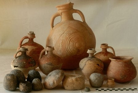
Pottery and loomweights found on Hellenistic floor, mid-2nd century BCE
One of the great advances of the last twenty years in archaeology has been the development of an array of remote sensing techniques that, in certain circumstances, allow us to “see below the surface” before excavating. Certain techniques work better than others at a given site, depending on the nature of the remains and the geology of the area, and a third goal of our 1997 season was to assess the geological profile of the site in order to determine what kind of remote sensing techniques, if any, would be useful. Midway through the season we brought in geoarchaeologist Arlene Miller Rosen from Beer Sheva University to act as a consultant on the geology of the tel and its amenability to various remote sensing technologies. In Rosen’s judgment, the nature and depth of the deposits make the site an excellent candidate for magnetometry, a technique that works by discriminating between the differing levels of magnetism given off by stone walls and their surrounding soil.