
After discovering the viability of magnetometry to reveal possible structures beneath the surface of the site, we contacted Dr. Lew Somers of Geoscan Research, one of the foremost practitioners of archaeological remote sensing. After studying our plans and photographs, Somers estimated that he could conduct a magnetometric survey of the lower tel in five to eight days with the help of two students. He was available to work over our spring break in March, and we decided to combine that work with topographic mapping of the upper tel and surrounding valley.
Ramot Naftali Dig House in 1998
The University of Michigan LS&A Undergraduate Research Opportunity Program (UROP) funded three students to take part in the project. Luckily Geoff Compton was on his way back from fieldwork in Egypt at that time, and we were able to divert him to Israel to reestablish the grid plan and continue the topographic survey. On the first day of spring break David Stone, a recent IPCAA graduate, and Professor Herbert, along with three LS&A archaeology undergraduates–Adam Hyatt, Mandy Leins, and Will Pestle–headed off to Israel to rendezvous with Geoff and Lew. We arrived at the site early on March 3 and had reestablished the grid plan by March 5, when Lew Somers arrived. We then began the magnetometric survey and continued the topographic mapping, with the undergraduate members of the team rotating between the two jobs. We were able to gather the magnetometric data on seven to nine 20 x 20 m grid squares each day. In the evenings, back at our rooms in the guest house in the nearby Moshav of Ramot Naftali, we started to process the results and produced rough maps. We completed the survey by the morning of March 11 and that afternoon headed off to the Tel Aviv airport to catch a flight back to Ann Arbor in time for afternoon classes on March 12.

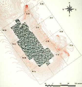
Lew Somers and team conducting magnetometric survey at Kedesh in March 1998.
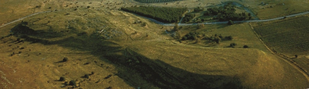
The preliminary results of the magnetometry have revealed the outlines of several large building complexes and what looks like a fairly regular north-south village grid plan. An impressive structure is showing up in the southeast quadrant of the tel, adjacent to the well-preserved remains in our 1997 southern probe.
Results of magnetometry, lower tel of Kedesh, March 1998