
This section of the website presents an overview of the fieldwork of the Gabii Project, beginning with the first campaign of geophysical survey in the summer of 2007.
2007 field season

Results of the 2007 magnetometry survey.
Results of the 2007 magnetometry survey.In the summer of 2007 the Gabii Project began its fieldwork at the site of ancient Gabii. The site offered attractive possibilities to our research team, especially since the principal investigators all share a deep interest in the origins of urban culture in Central Italy during the first millennium BC. The ancient city of Gabii offered a unique archaeological situation – although it had been explored to a limited extent by means of archaeological field survey and traditional excavation, it seemed as though a largely unstudied archaeological resource was at hand. Coupled with the excellent visibility on-site – owing to the reduced imprint of Imperial Roman construction and the abandonment of the city after the 10th century – the possibilities for broad, well-preserved archaeological horizons seemed likely. Thus the 2007 season marked the beginning of a process designed to ascertain the nature and viability of those archaeological deposits. A tract of limited size – ca. 8 ha – was chosen for the initial geophysical survey using magnetometry. The areas was surveyed in concert with the British School at Rome (BSR) and the Archaeological Prospection Services of Southhampton (APSS). APSS carried out the magentometry on contract and produced the preliminary plan (below) that suggested a) good preservation of subsurface features, including those connected with the urban layout and b) magnetometry wasa viable technology for the site. The initial results were presented via a poster at the January 2008 meetings of the Archaeological Institute of America in Chicago, Illinois.
2008 field season
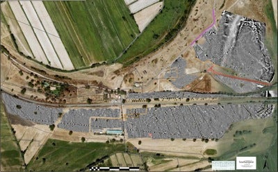
Preliminary results of the 2007-2008 magnetometry survey.
Preliminary results of the 2007-2008 magnetometry survey.With the results from 2007 in hand, the team returned to Gabii in the summer of 2008 to expand the coverage of the geophysical survey in an attempt to survey the entire archaeologically visible area with the hypothesized line of Gabii’s ancient city walls for an extension of nearly 40 ha. Again APSS provided the services to complete the magnetometry survey. In concert with the magnetometry, the team carried out a bore-hole survey designed by Marcello Mogetta (Michigan) to sample the archaeological horizons and their degree of preservation across the site. This manual bore-hole survey was augmented by several mechnical bore-holes all of which, taken together, allowed for the construction of two cross-site stratigraphical profiles and also suggested, like the magnetometry, that the sub-surface preservation of archaeological features was good. The APSS survey data revealed, among other features, the presence of an orthogonal grid-plan of the city. The results of the two seasons of survey were published in the American Journal of Archaeology in October 2009.
2009 field season
May of 2009 marked the beginning of the second phase of work by the Gabii Project. Granted permission by the Italian state, the Gabii Project opened the first of a series of five field campaigns concentrating on two 1-hectare areas selected on the basis of the survey data for their likely excellent preservation of archaeological features.
The main excavation area explored in 2009 was chosen so as to explore one of the radial side streets identified in the geophysical survey. Effectively two city blocks were exposed in the 2009 excavation, comprising a surface area of ca. 9,000 sq. meters. Three main sectors were explored in relation to the side street, each presenting unique archaeological situations.
Follow this link for a digested summary of media coverage of the lead sarcophagus excavated at Gabii in 2009.
2010 field season
In 2010 work at Gabii continued on two areas of investigation. In the main excavation area, work resumed within three separate stratigraphic basins that were initially identified and opened in 2009. These sectors, identified as Areas A, B, and C, respectively, continue to provide evidence for multi-phase use of the site of Gabii and all demonstrate a complex site formation process in which the destructive intervention of both natural weathering processes and mechanical erosion have played a significant role. Area A, the locus in which two elite Sub-Geometric infant burials were discovered in 2009, continued to offer evidence for an occupational sequence that is centered on an oblong structure whose limits are defined by a system of channels cut directly into the bedrock of the slope of the crater of Castiglione. These occupation levels contained a sequence of floors fashioned in crushed tufo. In Area B, a locus that thus far has proven to contain ca. 25 Imperial inhumations – including a massive lead sarcophagus excavated in July 2009 – has proven to be the site of a multi-phase structure, possibly domestic in nature, that includes a number of rooms as well as a tufo-paved courtyard containing a well shaft cut into the bedrock. The ashlar masonry of the structure suggests that its initial phase may belong to the middle Republican period, but subsequent use, re-use, and modification complicate the picture. The final phase of the structure may belong to the late 1st century AD, at some point after which the sector of the city that contains the house seems to make the transition from occupied zone to ad hoc necropolis. A number of possible tree-planting pits may suggest a post-abandonment landscape program that could be connected with the contracted Imperial urban nucleus that is presumed to lie along the line of the ancient Via Praenestina. Area C is a locus delimited by two side streets of Gabii’s urban grid that were discovered via geophysical survey in 2007 and 2008 (viz. Becker et al. 2009). Contained within the block is a multi-phase architectural complex whose last phase seems to be industrial in nature, perhaps a fullonica. Earlier structures in ashlar masonry are also evident; these are in phase with floors in cocciopesto. A feature of significant interest in the western part of Area C was a monumental rock-cut tomb that contained two adults; an adult female was deposited in a monolithic tufo sarcophagus while an adult male was found in a stone-cut loculus. The tomb belongs perhaps to a pre-5th c. BC phase of the area as adjacent structures are truncated by the creation of the quasi-orthogonal grid of streets, for which the terminus post quem is the 5th c. BC; ceramics recovered from the fill of the tomb’s cut suggests a date in the first half of the 5th c. BC. Area C also shows, by way of residual pottery, evidence for significant Iron Age activity – and perhaps occupation – in this part of the site. Investigation of these three areas will continue in 2011.
2011 field season
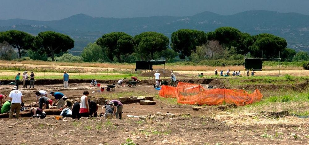
In the summer of 2011 the Gabii Project completed its third consecutive season of excavation and fifth overall fieldwork campaign in the ancient Latin city of Gabii. Over the course of three campaigns, a nearly 1-hectare area has been explored by means of excavation. In 2011 a team of over 90 students and archaeologists participated in the work of the project. The 2011 season involved the continued exploration of significant tracts of the city center that were initially opened in 2009, with some portions being subsequently expanded in 2010 and 2011. This summary proceeds in order of overall chronology. For the early first millennium BC the previous excavation [2009] of elite infant tombs (see Becker and Nowlin 2011) signalled the presence of social stratification during the later eighth and seventh centuries BC. Now a series of seventh and sixth century BC occupation horizons within an elite compound points to the continuation of earlier traditions of social complexity. In addition, the deposition of numerous intramural adult inhumation burials in the post-abandonment levels of this elite compound suggests not only that a re-appraisal of adult intramural burial in the archaic period is required but also that the autonomous actions on the part of elites may have played a significant role in the archaic city. The abandonment of archaic levels gives way to a re-planned urban center with a quasi-orthogonal layout, an occurrence of the later fifth to early fourth centuries BC (see Becker, Mogetta, and Terrenato 2009; Mogetta forthcoming). The evidence for this layout was first detected by means of the Gabii Project’s geophysical survey (2007 and 2008; see Becker, Mogetta, and Terrenato 2009; Terrenato et al. 2010) and confirmed by means of the excavation of portions of three side streets. This Republican phase of the city is yielding significant evidence for Mid-Republican architecture with three buildings being excavated in two separate sectors. The early phases of these structures are marked by well-dressed ashlar masonry, paved interior floor surfaces, and the use of massive, monolithic tufo slab pavements around wells and cisterns. These structures are multi-phased and see re-use and re-building until at least the first century AD. The Imperial levels explored so far have yielded over 30 inhumation tombs, most of which are consolidated in an area that seems to be an ad hoc necropolis from the first century AD onward. Remarkable among them is a trio of tombs in which the deceased in encased in lead sheeting; one such tomb was excavated in 2009 and two additional tombs came to light in 2011. This cemetery demonstrates evidence for the contraction of the Imperial city, precipitated at least in part by the activities related to massive quarries along the rim of the Castiglione crater that aimed at exploiting the local bedrock, lapis Gabinus (a type of peperino tufo).
2012 field season
The fourth season of excavation at Gabii saw the participation of over 70 archaeologists and students. The investigations concentrated on the sector occupied by the Archaic elite compound (Area D), and on the city-block adjacent to the Republican houses excavated in 2010-2011 in Area B (Area F). The stratigraphical sequence excavated in Area D revealed an occupation level of the early sixth century BC. In this phase the habitation complex appears delimited on three sides by a precinct wall built with large slabs of local volcanic stone. This surrounded a large room and an open area featuring hearths. Infant burials are associated with the compound. New evidence of the Orientalizing period was uncovered below this stratum, including a rich infant burial dating to the middle of the eight century BC with a grave goods assemblage very similar to the that of the infant tomb excavated in Area A in 2009 (Becker and Nowlin 2011). In Area F a large building has been identified west of another north-south road of the orthogonal layout. This is composed of two axial terraces. The lower one is partly dug into the sloping bedrock. The construction cut is lined with a monumental ashlar wall (built with lapis gabinus), whose upper part also serves as the retaining wall for the upper terrace. This is occupied by an open court delimited by polygonal masonry structures. Plan and construction techniques suggest that this was a public building, dating to the Republican period. The Gabii Project plans to explore other portions of both areas in 2013.
2013 field season
In the fifth season, excavation activities continued in both Area D and Area F.
In Area D, the remains of an occupation level predating the archaic house have been explored. A complex sequence of hut floors and other features are coming to light, attesting the continuity of elite occupation in this area from the earliest stages of the formation of the city. Another infant burial has been found associated with this residential compound. The grave goods are some of the richest in Central Italy and provide important evidence about the social status of the lineage that resided in the area. In Area F, other parts of the major complex discovered in 2012 have been exposed, clarifying the plan and sequence of construction. Its date in the late fourth or third century BC makes it a rare instance of a presumably public complex in Middle Republican urbanism and architecture.The monumental building is articulated in two terraces separated by a massive retaining wall of ashlar blocks. The lower terrace, of which the west side has been excavated, includes a paved courtyard onto which vast rooms open. These are decorated with opus signinum floors and wall-paintings in the First Style. A monumental pillared façade frames the south side of the building, which faces the main thoroughfare of the urban layout.
2014-2015 field seasons
In the last two seasons of work at Gabii, the excavation of both Area D and Area F has been completed, and a program of site conservation and preservation has been launched. The investigation of Area C was resumed in 2015, with the goal to explore the levels beneath the Republican houses.
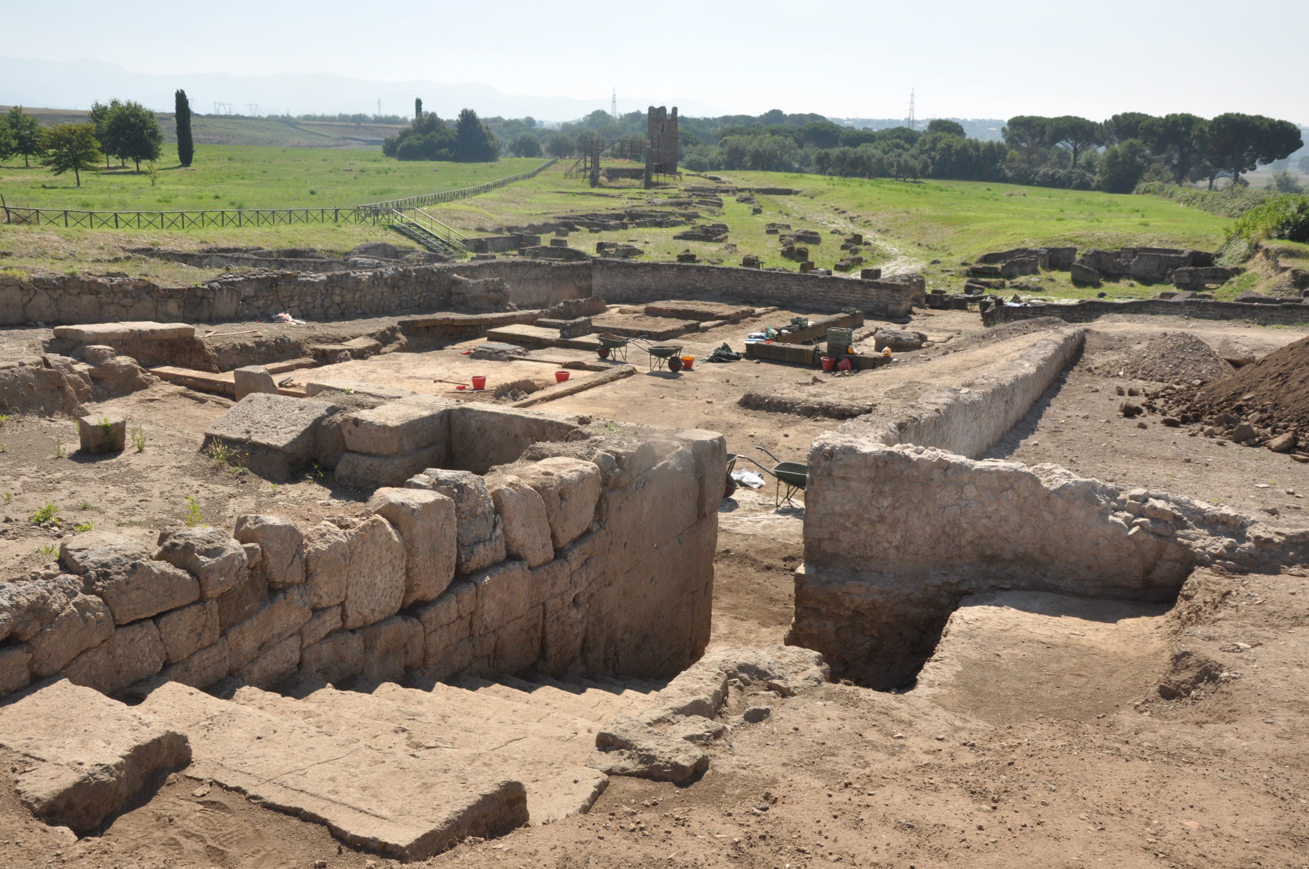
View of the Area F building from the upper terrace (2013)
View of the Area F building from the upper terrace (2013)