
The investigation of ancient caribou hunting on the Alpena-Amberley Ridge has followed a layered strategy.
1) It begins by modeling the ancient land surface and its environment, followed by acoustic survey to locate potential hunting features.
2) Promising acoustic targets are further investigated using a remote operated vehicle (ROV), equipped with high definition cameras so that researchers can visually confirm that the identified features are potentially cultural.
3) The next step is to directly examination potential archaeological features with SCUBA trained archaeologists.
4) If the divers determine that the features have archaeological potential — along with collecting samples at that location — this will spur more fine-grained examination of the locality. This often involves using an Autonomous underwater vehicle (AUV) to create a very detailed sonar map of an area.
5) Along with archaeological investigations, this project studies the evolution of the ecology of lake Huron. This involves a multitude of scientific techniques, including ones designed to characterize the paleo-environment, such as the identification of testate amoebae, and geomorphic examinations of landforms.

1) Detailed sonar images are made of the lake bottom. Sonar instruments send out sound waves that reflect off of objects back to the machine. Differences in how long the sound wave takes to get back to the machine from different directions is used by a computer to make of the area.
The AAR was once a terrestrial landscape with lakes, rivers, forests and swamps. Through sonar surveys the team is able to partly reconstruct this ancient landscape.
Sandy bottom water bodies show up darker on the sonar map because sand (which would have been lakes) does not reflect the sonar wave as much as the hard rock around it. Maps like these help the team predict where sites might be located so that they can proceed to the next phase of the investigation. See below…

2) The ROV’s name is Jake and he has his own Facebook page! In order to mark the location where sample were collected — so that they can be found later — floating tags with numbers are placed on the bottom of the lake.

3) Here divers examine potential stone structures that were identified from the sonar imagery. You can see Jake hiding there to the right of the rock. Researchers on the boat operate Jake the ROV while the dive operation is in progress. This allows the dive to be observed in real time and for the divers to communicate information to the people on the boat during the dive. Jake also records everything he sees in High Definition so the team can review the footage later.


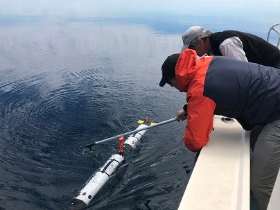
4) An AUV operated by Michigan Tech University in the Upper Peninsula, is often employed to make more fine-grained sonar map of the area. The AUV looks like a torpedo, and considering how high tech the whole AUV system is, there should be a better way of getting it back onto the boat….
In addition to mapping stone structures and searching for material culture debris, wood and sediment samples were collected in a number of locations. These samples not only provided important environmental data in the form of pollen and testate amoebae, those collected within and around the hunting structures have also yielded water rolled flakes, chert and quartzite micro-debitage, charcoal, bone fragments, and preserved wood. While this search strategy works well for discovering stone arrangements, the pervasive coverage of the bottom with invasive mussel species has made the recovery of less pronounced features or small artifacts much more challenging.