Hannah Pethen, who works as a GIS specialist on the project, explains the process of developing and implementing new GIS applications for the project.
During this season’s fieldwork at Olynthos we tested a new app that allows archaeologists to record locational data in the field on a smartphone or tablet and synchronise the resulting data with the project’s Geographic Information System (GIS) that we use to manage all the excavation data.
There have long been efforts to replace large and complex survey kits with smaller handheld devices, but these used to involve considerable cost or required advanced programming skills. The advent of mobile phone and tablet compatible mobile-GIS apps has opened a range of new possibilities for recording fieldwork directly in a mobile-GIS platform, synced to your online or desktop GIS.
The Olynthos project has typically used total stations for recording on site and printouts of Google Earth for identifying surveyed fields, with data from both sources incorporated into the project GIS in subsequent stages. Tablet and smartphone based mobile-GIS survey is not appropriate for precise recording of archaeological features in the excavation trenches, as GPS units integrated into tablet computers are only precise to c. 2.5-5m (for a review of external high precision GPS devices that are compatible see this blog). But once combined with a satellite image basemap, this level of precision is perfectly acceptable for recording surveyed fields in the surrounding countryside or surface collection in grid squares on the unexcavated parts of the site.
The Olynthos Project used the ArcGIS Collector app. Peter Knoop and Caitlin Dickinson of the University of Michigan’s College of Literature, Science, and the Arts Information Technology team set up this app to sync to the Olynthos Group on the University of Michigan ArcGIS Online account. In the field we trialled the app on a tablet and a smartphone and had very positive results. ArcGIS Collector is essentially a simplified version of its big brother ArcGIS desktop, optimised for field data collection on a small mobile device with limited connectivity and processing power. The principles are straightforward. We produced layers in ArcGIS desktop, published them as service on the ArcGIS Online account, and created maps from them in ArcGIS Online, which were then downloaded onto ArcGIS Collector in a format that is suitable for smaller screens and simpler for mobile devices to process.
We found the process of creating layers in ArcGIS desktop, uploading them to ArcGIS Online and creating maps for ArcGIS Collector a little cumbersome and confusing. It’s easy to upload a layer but then fail to share or publish it correctly for you or others to view or edit it in Collector. This can be irritating, but once you’ve created one map for Collector, familiarity makes the process a lot easier.
Within the Collector app, the interface is clean and easy to use and using the app in the field is incredibly simple and straightforward. Once the app is linked to your ArcGIS Online account it identifies all the maps you and others in your organisation/group have created and offers you the opportunity to collect data using them. You can use Collector with a permanent wifi or mobile-data link to ArcGIS Online, but we found downloading the maps onto our mobile devices was more efficient and saved mobile-data charges.
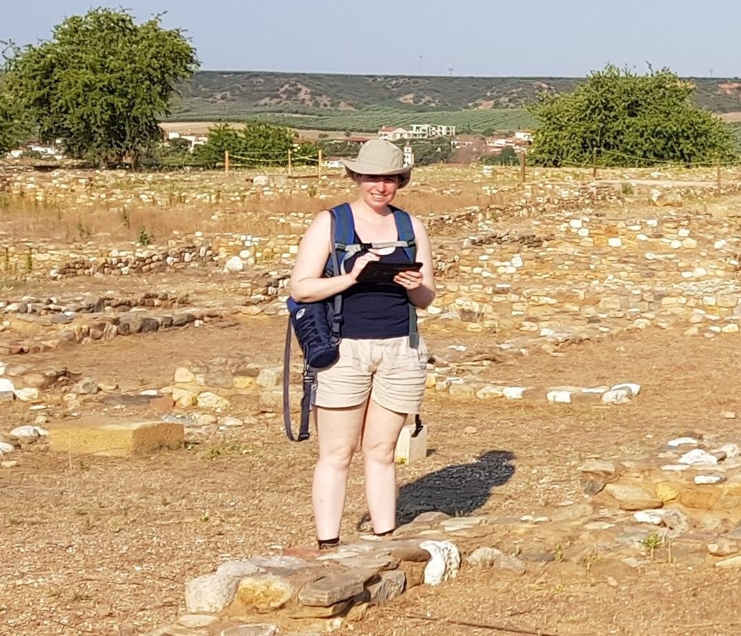
Surveying at Olynthos using a GPS-enabled tablet and ArcGIS Collector
The process of viewing, selecting, editing and creating features within the Collector app is generally slick and comfortable but a major issue is that it doesn’t currently support snapping. This necessitates various topological checks and editing of your data in ArcGIS desktop after you’ve downloaded it. This was a serious deficiency in the ArcGIS Collector format when digitising the surveyed fields around Olynthos, but it didn’t affect point data collection of archaeological features on the site.
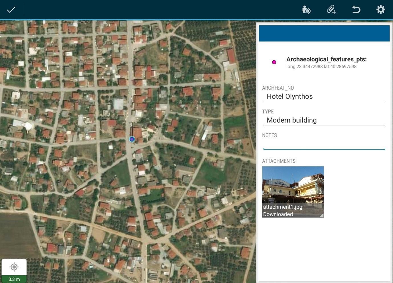
The ArcGIS Collector interface showing point collection, attributes and photo
The preceding image shows a test of the ArcGIS Collector interface as I recorded a hotel in the nearby village. As you can see the app even supports the inclusion of a photograph.
Overall we found that ArcGIS Collector was a straightforward app to use. Although the need to run the data through ArcGIS Online is slightly irritating and predisposes the process to additional errors, it was otherwise a relatively ergonomic platform. The Collector app isn’t perfect, the absence of snapping is a serious defect in my opinion and it crashed a couple of times, but it does speed up data collection in the field and reduces data entry in the office.
Results
We were able to successfully integrate ArcGIS Collector into our phones and a GPS-enabled tablet to record fields surveyed in the area around Olynthos, and squares of the site grid where surface artefacts had been collected for analysis. Adding an additional layer for archaeological features that were seen but did not form part of the artefact collection was also helpful. The following image shows the ArcGIS Collector interface with the data collected so far overlaid on ESRI ArcGIS Imagery. The two hills that make up the site are left of centre in the image, covered by the cross-hatching of the site grid. The conservation area of ancient Olynthian houses is the light rectangle in the centre of the north hill. To the south of it are the grid collection points where surface artefacts were collected. Surrounding the site on three sides are the many fields that have been subject to surface survey over the past three seasons. New areas of survey are currently being added to the right of the image.

Field walkover survey and grid collection point data from the current fieldwork season, shown in the ArcGIS Collector interface overlying ESRI Imagery basemap
The future of field survey?
We will continue to gather field survey and grid collection data using the ArcGIS Collector app. It dramatically sped up the process of field data collection and eliminated the need for entering data into a digital system upon return from the field, saving time that can be profitably used for other important tasks. While onboard phone and tablet GPS is insufficiently precise to collect excavation data we will continue to need the services of our total station surveyors, but in the areas where a lower precision is acceptable or are inaccessible to total stations ArcGIS Collector provides us with a useful replacement. As GPS continues to improve, we may one day be recording everything with this type of app.