 Purposes of the E. S. George Reserve
The ESGR is maintained by the University for the purposes of (1) providing research and education opportunities in the natural sciences, and of (2) preserving and demonstrating the native fauna and flora. It is used primarily for natural history study and other ecological investigations by students and staff of the University and by visiting scientists from other institutions. The ESGR land is enclosed by a fence which is kept locked at all times, however, interested and qualified persons can obtain access by arrangement with the Director.
> History > Physiography > Climate > Vegetation > Soils
> Human-induced changes > Deer herd
History
Before 1927, the area comprised about a dozen farms with tilled fields, small orchards, wood lots, pastures, and swamplands. Clearing and tillage were largely restricted to the level upland and more gentle slopes. The woodlots and marshes were pastured, and the woodlots were moderately used for firewood. In 1927, the tract was purchased and fenced as a game reserve by Colonel Edwin S. George. In 1930, it was presented by him to the University of Michigan, which has maintained it since as a wildlife sanctuary, research area, and teaching resource under the supervision of a Director in the Department of Ecology and Evolutionary Biology, College of Literature, Science and the Arts (LSA).
Physiography
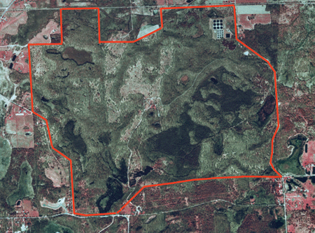
 The ESGR includes approximately 525 hectares of rugged moraine and basin topography. Except for some 125 ha of high level plain in the north central part, and a steep, esker-like ridge that extends from the southern end of this plain to the northeastern corner of the ESGR, hills and knobs alternate with kettle holes and basins. The extremes of altitude are from 890 to 1000 feet, with approximately 15% of the area below the 900 ft. contour line and another 10% below 915 ft. The Reserve lies on the north edge of an interlobate morainic region. Just south of it is a spur formed by the junction of the Kalamazoo moraine extending to the southwest and the Mississinawa moraine extending towards the south. To the north is the Pinckney Channel, through which the glacial Huron River flowed, draining to the south and west. The south terrace of this old river bed borders the north edge of the ESGR. Drainage, which for the most part is good, is by water filtering through the sandy soils. Lowland, depending on its elevation, is under water temporarily or permanantly. Wetlands of the ESGR include several permanent to semi-permanent impoundments, a bog lake in Big Swamp, many smaller temporary ponds, mostly in the woods,and four springs.
Climate
The present-day climate of the region in which the ESGR is located is a humid type characterized by low thermal efficiency and by rainfall throughout the year. The prevailing average annual precipitation is about 30 inches and the range of mean monthly temperatures is from approximately 22°F in January to about 72°F in June and July. The growing season is 145 days.
Vegetation
The vegetative cover of the ESGR has undergone a major shift as reforestation has progressed. In 1937 the lands of the ESGR were 43% grassland and 30% forest. By 1995, only 16% of the ESGR was grassland while 60% was forested.
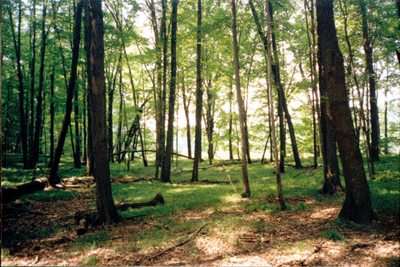 There are two main upland vegetation types: grassy old fields and oak-hickory woodlands. The grasslands occupy the flats and gentler slopes, where the early settlers cleared the forests and are being rapidly colonized by the invasive autumn olive. The forested areas are all second-growth, chiefly oak and hickory. About 23% of the ESGR is wetland, with almost half of that being wooded bog swamps. The remaining lowlands offer a great diversity of aquatic habitat-types, including grass-sedge, grass-sedge-scrub, and cattail marshes, buttonbush pot-holes, three leatherleaf bogs, three tamarack swamps, a yellow-birch swamp, and a maple-elm swamp.
Soils
The ESGR lies within the Miami-Kewaunee soil area, and its soils are varied and patchy in distribution. The uplands down to the level of the 900-ft. contour line are covered with mineral soils, including the Bellefontaine sandy loam, Plainfield sandy loam, and Coloma loamy sand. A few small patches of Miami loam are principally in the eastern, southern, and western parts of the Reserve. Nearly all of the land below the 900-ft. elevation is covered with soils composed of organic peats and mucks deposited in bogs, marshes, and swaps; the accumulation is often of considerable depth. These organic soils are classified as the highly acid Greenwood peat; the moderately acid Rifle peat, and the more neutral or even alkaline Carlisle and Kerston mucks.
Human-Induced Changes
Many of the larger and better trees on the lands of the ESGR were taken from the woodlots about 1900 and in 1913 a number of white oaks and hickories, a foot or more in diameter, were taken from the northwest hardwoods. These and some tamaracks harvested from the Big Swamp appear to have been the only trees cut since 1900. No cutting has been done since the area was set aside as the ESGR. Pasturage of the woodlots, marshes, and swamps was generally prior to 1928 but was heaviest before 1900. Cultivation of the cleared fields of the uplands was quite extensive until about 1900. There have been no fires on the area since 1926. Drainage control has not been extensive; tiles were established in 1946 at the west and east ends of Crane Pond to maintain its water level, and in 1951 an extended ditch was developed to improve drainage east of the pond. Two earth dams, one built in 1965 cross the natural drainage of Big Swamp (creating East Marsh) and the other in 1967 to retain water in West Marsh (creating West Marsh Dam Pond), have added several acres of impounded water to the ESGR.
The Reserve Deer Herd
In March 1928, four does and two bucks of the White-tailed deer (Odocoileus virginianus) were released into the ESGR. From this basic stock, the deer population rose to more than 160 animals in 1933, creating heavy browsing pressure on the vegetation and suppressing natural plant succession. Since 1942, annual culling of the deer herd has been carried out, with a resulting slow but definite recuperation of the browsed vegetation. Before the herd was reduced in size, reproduction of less-palatable species such as red cedar and hawthorn was replacing that of the oaks, hickories and maple. As the range has recovered, browsing pressure on the less preferred species has decreased. The ESGR deer herd has been the focus of many studies, including Dale McCullough’s landmark book “The George Reserve deer herd: population ecology of a k-selected species.” This text continues to be a must-read for managers of large mammal populations.