Archaeological Research – The Kelsey Blog

Archaeological Research

The Kelsey welcomes visiting scholar Dr. Blondel

By Malloy Bower

The Kelsey gallery cases are filled with ancient artifacts from the Mediterranean and Middle Eastern regions, with more artifacts available to the public in drawers below the cases. A visitor might be overwhelmed if their goal is to experience every object on display! The objects in the gallery, however, represent a small portion of the collections at the Kelsey due to the limitations of display space. The remainder of our over 100,000 object collection resides in collections storage. 

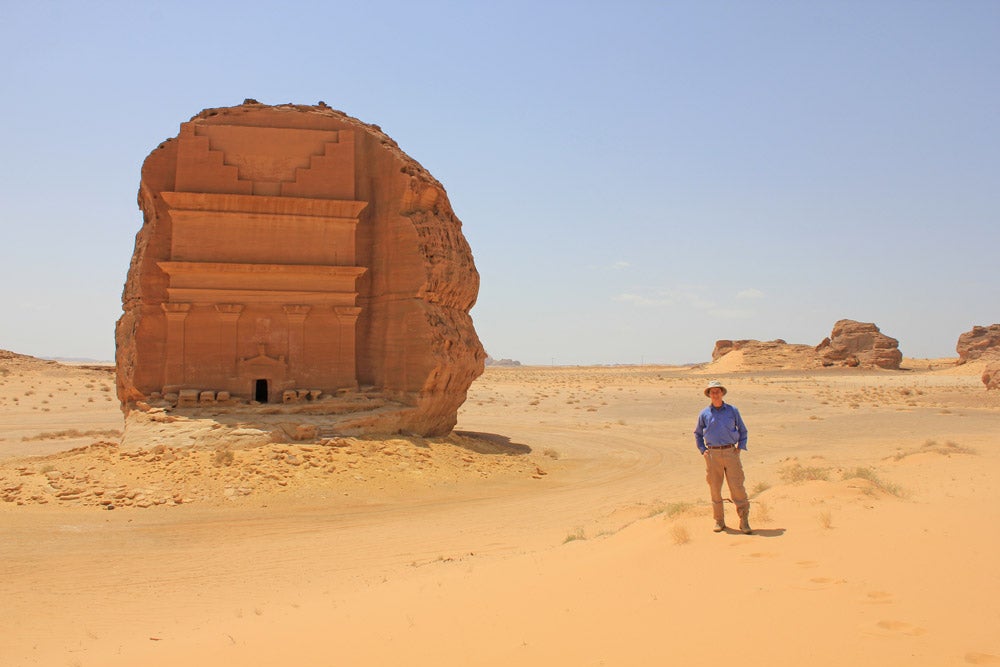
There are numerous reasons why certain objects remain in storage, but their potential for research and adding to our knowledge of the ancient Mediterranean and Middle East is not one of them. Researchers from all over the world travel to Ann Arbor to study the collection, each researcher approaching the objects with unique questions about the people who created, owned, and used the objects. In July 2022, researcher Dr. Francois Blondel from the University of Geneva spent several weeks at the Kelsey collecting tree-ring data from wooden objects excavated in Egypt that date to the Roman period (1st century BCE–5th century CE).

A middle aged bearded man in a black t-shirt sits at table in front of a large microscope, hands in his lap. He is looking at the camera and smiling.
Dr. Francois Blondel sitting at the binocular microscope in the Kelsey’s collection storage area.

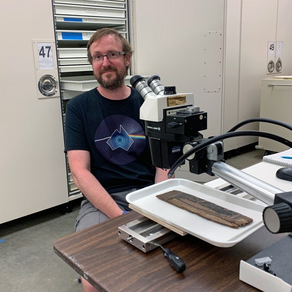
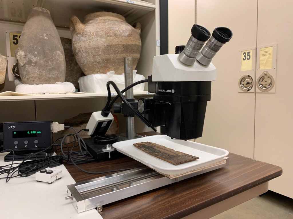
Using a binocular microscope and measuring table, Dr. Blondel measured the distance between tree rings observed on the wooden objects (including KM 88723, featured in June’s Ugly Object blog). With each press of a button to record the measurement, software, connected to the measuring table, creates (or draws) the growth curve of the wood (or its growth pattern) as it goes along. The resulting curve characterizes all the variations of ring widths in these ancient artifacts crafted from ancient trees. Dr. Blondel repeated this process at least three times with each object to obtain the most complete sequence possible and also to compensate for possible measurement errors due to the lack of ring legibility on some complex objects. This data will then be compared to a database of tree-ring measurements and interpreted by Dr. Blondel in a future academic paper to help date the objects. This process of using the growth rings of trees to date objects is called dendrochronology.  

We look forward to what his research uncovers about the ancient world and its people, and how the objects in our collections contribute to his findings! 

The Kelsey welcomes visiting scholar Dr. Blondel Read More »

#TrenchTalkTuesday — Get your archaeology questions answered!

Did you know that Kelsey Museum researchers and students participate in a broad array of archaeological field projects throughout the Mediterranean, Middle Eastern, and North African region? These excavations continue to enrich our understanding of the ancient world and give us a fuller view of the past. Archaeology uncovers, both figuratively and literally, new pieces of information that add to or alter our modern knowledge of ancient people and places. 

To bring more attention to the Kelsey’s active field projects, we want to answer your questions! Between Tuesday, August 9, and Wednesday, August 31, specialists at the Kelsey will answer all your questions about archaeology and fieldwork. Participating is easy. Search @KelseyMuseum on Twitter, Facebook, or Instagram, find one of our #TrenchTalkTuesday posts, and type your question in the comments field. Kelsey archaeologists and specialists will respond before the end of August. Your question might even be featured at the Kelsey Museum!

What would you like to know about archaeology? What ancient materials or objects would you like more information about? What about some of the field sites, like Gabii in Italy, Notion in Turkey, Abydos in Egypt, or Jebel Barkal in Sudan? Explore the Kelsey’s Current Field Projects web pages to get you started.

We look forward to your questions!

Not on social media? We still want to hear your questions! Email your archaeology-based questions to KelseyMuse@umich.edu before August 23, 2022.


#TrenchTalkTuesday — Get your archaeology questions answered! Read More »

New Podcast Interview and TED-Ed Animated Video from Geoff Emberling

Kelsey Associate Research Scientist Geoff Emberling has been busy! He’s featured on the October 7 episode of the podcast Tides of History, hosted by historian Patrick Wyman. In the 42-minute interview, Geoff talks about the long and fascinating history of Kush, the contentious nature of previous archaeological research in Sudan, how he came to work in the region, and his projects at El-Kurru and Jebel Barkal.

Geoff also served as the academic consultant for a TED-Ed video about Kush. Published on TED.com earlier this month, the beautifully illustrated video short outlines the rise and fall of this ancient African civilization.

New Podcast Interview and TED-Ed Animated Video from Geoff Emberling Read More »

New Kelsey Blog: The Social Lives of Coins

The Kelsey’s new assistant curator of numismatics, Irene Soto Marín, has launched a weekly blog called The Social Lives of Coins: Archaeology and Numismatics at the Kelsey. In it, she will highlight interesting discoveries she makes as she studies the 40,000+ coins in the Kelsey’s collection. Join Irene on an exciting journey into history as she explores the ancient world through the Kelsey’s one-of-a-kind numismatic collection. And don’t forget to subscribe so you never miss a post!

New Kelsey Blog: The Social Lives of Coins Read More »

News from the Conservation Lab — Kelsey Dig Wanderlust

By Suzanne Davis, Curator of Conservation, and Carrie Roberts, Conservator

The inability to travel to the Kelsey’s field sites due to the COVID-19 pandemic has made us, well, crazy to travel to the Kelsey’s field sites. If you, too, are experiencing serious wanderlust, we invite you to take a quick photographic mini-break with us. Here’s a beautiful photo and something we love about each of the four sites we currently support.


Suzanne loves the incredibly good-looking site of Notion, Turkey. It’s got everything a conservator could want — the romantic ruins of an entire ancient city, lots of conservation work to be done, and a beautiful seaside location.

View over a ridge with shrubs onto the ocean below
Notion, Turkey. View of the site from the west at sunset; the ancient city is located on top of the yellow, sunlit hill. If you look closely, you can see the Fortifications.


This spectacular photo of the ancient temple, cemetery, and city site of Jebel Barkal, Sudan, makes Suzanne miss the desert sunshine and all her fellow Jebel Barkal and El-Kurru teammates.

aerial view of small pyramids in the desert
Jebel Barkal, Sudan. This image shows the remains of some of the site’s pyramids, with Jebel Barkal (in Arabic – the holy, or pure, mountain) in the background. Photo by Kate Rose.


Carrie is inspired by the ancient landscape of Abydos. It’s great to drink a cup of coffee with the team at sunrise and know that the Seti I temple is only a 10-minute walk from the dig house, while the early dynastic tombs below the desert cliffs can be reached in 20 minutes.

photo of a house in the desert
View of the front courtyard of the Abydos dig house at sunrise.


At El-Kurru, Carrie loves village life — walking from the house where we live to the temple site and saying hello and how are you to neighbors on the way, then grabbing a snack at the corner store at the end of the day. She also misses the family we live with, especially the kids.

men in front of a low beige building in Sudan
El-Kurru, Sudan. On the left is Kurru’s hardware store, and on the right is the barbershop.

News from the Conservation Lab — Kelsey Dig Wanderlust Read More »

aerial view of magnetometry results

International Kurru Archaeological Project — Fieldwork Friday #4

End of the season and some results!

desert landscape with pyramids
Sun setting across the desert landscape from the top of Jebel Barkal, with the pyramids in the midground.

15 February 2019

By Gregory Tucker

I was hoping to submit this last blog post on my time in Sudan, sharing some of our results, as I left the country on 21 December 2018, but unfortunately some rather significant events occurred and I had to leave the country early. On the 19th and 20th of December, protests erupted across the country with various motives that I will not focus on in this post, but I encourage you to read up about these events here and here. I was on my way to Khartoum during this period and while there I was advised to stay in the hotel and to leave the country on the earliest flight possible. In the end, I had no trouble at all leaving Sudan and saw no signs of the protests or their aftermath on the streets from the hotel to the airport, and I was very glad to arrive safely back home to news from my Sudanese friends and colleagues that they were all safe and in good health. Since I left, other research projects have continued to visit Sudan, such as the Uronarti Regional Archaeology Project, although the protests have continued off and on. These protests have recently resumed after a period of relative calm and I hope that the Michigan team now in Sudan stays safe and out of trouble!

magnetometry results
The results of our survey work in December 2018 as part of the University of Michigan-led project!

In the image above, you can see the results of this season of geophysical survey and how it relates to the large Temple of Amun, visible in the left center of the image, and to the palm line to the lower right. This season of geophysics at Jebel Barkal was successful in defining a large number of archaeological features of interest, some of which are being investigated more intensively right now by other members of the project team on site. One of these is shown in more detail in the figure below, which zooms in on the center of the larger area of gray results in the larger image. What is most significant are the straight lines and right angles formed by the lighter and darker pixels, which reflect differing magnetic readings across the surface.

aerial view of magnetometry results
Results from the center of the survey area, showing rectilinear anomalies that likely define a buried structure, not visible on the surface.

More detailed results and analysis of this survey season will be published after thorough analysis, interpretation, and comparison with the excavation results. It was a fantastic field season, even with the hot weather at the beginning and the other obstacles we encountered. At times I didn’t think that we would complete everything we set out to do, but in the end we did even more than we targeted — a rare event in my experience!

selfie with archaeological ruins in background
A final selfie over the site from the top of Jebel Barkal, including the Temple of Amun in the foreground and the main survey area in the near distance to the upper left of the image.

Many thanks are due to the many people who made this fieldwork possible. First of all, I want to thank my assistants in the field, Bakri Abdelmonim and Abdelbaqi Salaheddin Mohamend, who I have worked with now for many years and whose experience and expertise make my job significantly easier. Thanks also to Sami Elamin, our NCAM (National Corporation for Antiquities and Museums of Sudan) inspector, who helped me to organize work on site as well as my day-to-day life while in Sudan, and who invited me to many social events in El Kurru and nearby towns and cities, including me as much as possible in the life of the region. Many thanks to everyone in El Kurru who welcomed me during the month of fieldwork and have always welcomed me — it feels like a home away from home when I am there. I would like to also thank our project’s overall director, Geoff Emberling (University of Michigan), for supporting my work from the very start. Hopefully we’ll make many more discoveries together. Finally, the greatest of thanks are due to Larry and Julie Bernstein for the financial support that made this work possible, we could not have done it without your generosity.

Camels on a road
Camels on the highway on the trip back to Khartoum.

International Kurru Archaeological Project — Fieldwork Friday #4 Read More »

View of pyramids in desert.

International Kurru Archaeological Project — Fieldwork Friday #2

Magnetic Gradiometry at Jebel Barkal

Man walking in desert with scientific equipment, pyramids in background
Collecting magnetic data on our first day of survey at Jebel Barkal. Photo by Abdelbaki Salahadin Mohamend.

7 December 2018

By Gregory Tucker

This week for #fieldworkfriday I would like to share with you a bit of where I am and what I’m doing in the field. This month I’ve come to Sudan’s Northern State, to the site of Jebel Barkal, near the Fourth Cataract of the Nile, to conduct a geophysical survey in two distinct areas of the site.

Map of Sudan.
Map of Sudan showing the location of Jebel Barkal.

Jebel Barkal is a small mountain not far from the Nile that was considered by the Egyptians and later the Kushites to be the home of the god Amun. Various temples, palaces, and pyramids were constructed at the site from the Egyptian New Kingdom (about 1500 BCE) to the end of the empire of Kush (about 300 CE), and these have been the targets of extensive excavation in modern times. Jebel Barkal and the nearby sites of El Kurru, Sanam, and Zuma are on the UNESCO World Heritage List.

photo of wall of Egyptian temple.
This image, which I took just yesterday, shows the amazing conservation work of the Italian-Sudanese team at the Mut Temple at Jebel Barkal. The image on the left has been cleaned and clearly shows Taharqa, while the image on the neighboring wall on the right is still covered in soot.

White vans at base of mountain.
It’s tourism season in Sudan, as evidenced by the many vehicles bringing tourists to visit the site every day. Seeing this many together is rare, however, even this time of year!

Geophysical survey is one of the most efficient ways to explore a large landscape like that of Jebel Barkal in search of specific features that will help us understand how people lived in the past. The results of this month of survey will help our projects better understand and interpret the built environment of the site, shedding light on how the community at Jebel Barkal lived and how it relates to other sites and their architectural traditions from the region.

This past week we finished up our work for the first project, on the south side of the mountain, where we were working in the desert landscape near the pyramids at the site.  We were invited to survey this area by Murtada Bushara Mohamed of Sudan’s National Corporation for Antiquities and Museums (NCAM) as part of the Qatari Mission for the Pyramids of Sudan (QMPS) project. This project is focused on research, preservation, and presentation of the pyramids at Jebel Barkal, Kurru, Meroe, and Nuri and our contribution will help us better understand the landscape context of these monuments by identifying the location of other structures in this region of Jebel Barkal.

View of pyramids in desert.
The pyramids on the southern side of Jebel Barkal.

Tomorrow we will begin our work on the east side of the jebel, between the mountain and the Nile River, in an area we call the “East Mound.”  This project is an offshoot of Geoff Emberling’s research at El Kurru and the surrounding region, and during preliminary research conducted in 2016 we identified this mound as being a likely location for the settlement associated with the temples and palaces of the monumental core of the site.[1]  We were able to identify buried structures here during a very short period of survey that year, just a couple of days, so we have returned to survey the entire mound and the surrounding area to better define the extent of this settlement.

scientific equipment at base of rock outcrop in desert.
View toward Jebel Barkal from the “East Mound” as we begin to set up our equipment for the survey work in this area.

The type of prospection that I’m conducting can be done with many different instruments, each with its own unique method of collecting magnetic data. In the case of this project I am using a device that must be carried across the landscape and takes readings at consistent intervals.

The most efficient way to use this device is to set up a grid in the area that we wish to cover. Using a total station we establish a 30 x 30 m grid, and within that grid we lay down guidelines that are marked at every meter. Then, wearing the scientific device, I walk up and down along the guidelines, which are there to ensure that I walk straight and at a consistent pace.

By telling the instrument and the processing software the parameters of the survey, the data can be plotted quite quickly to create a map of the magnetic readings at the surface, giving us insight into what may lie buried below. With this particular machine we are limited only by how fast I can walk while maintaining a consistent pace and holding the machine relatively steady, which depends on the surface conditions — sand slows me down quite a lot! — and how well we have established the grid and the guidelines. Below is a short video that gives a first-person perspective of what walking one of these lines is like. (In a typical day I can walk approximately 540 lines!)

Of course, there is slightly more to it than just that, but the bulk of my time here is spent walking along these lines and listening to the machine chirp at me, 30 meters at a time.

I realize that I did not check the comments on my last post to see if there were any questions, but I will be better about that this week, so please comment with any questions you may have or email me at gstucker@umich.edu. I would love to hear from you! And please check in next week for another update from Sudan!

 * * * * *

[1] This research was undertaken thanks to a Waitt Grant from the National Geographic Society for my project: “Defining Settlement in the Nile Valley: Geophysical Prospection in the Region of Jebel Barkal, Ancient Napata.” For more about the results of this work, see Tucker and Emberling, “Settlement in the Heartland of Napatan Kush: Preliminary Results of Magnetic Gradiometry at El-Kurru, Sanam, and Jebel Barkal,” Sudan & Nubia 20 (2016): 16–22.

International Kurru Archaeological Project — Fieldwork Friday #2 Read More »

Desert scene with camel.

International Kurru Archaeological Project — Fieldwork Friday #1

The International Kurru Archaeological Project is back in the field!

1
Jebel Barkal in a photo taken during 2016 fieldwork.

30 November 2018

By Gregory Tucker

Welcome to the first of a series of blog posts that I plan on writing every Friday over the next few weeks for the Kelsey Museum’s #fieldworkfriday series! This happens to coincide perfectly with our rest day in the field, so I thought I could take the time to share with you a bit of what we’re up to this season in Sudan.

The International Kurru Archaeological Project has been an international project studying the ancient Nubian site of El Kurru in modern-day Sudan near the city of Karima since 2013. As part of this project I have been fortunate to have had the opportunity to conduct geophysical survey at El Kurru and the neighboring sites of Sanam and Jebel Barkal, to get a better understanding of the unexcavated areas of these sites without, or prior to, intensive excavation.[1]

In general, geophysical survey attempts to detect features beneath the surface by remotely sensing various properties at, or just above, the earth’s surface. Perhaps it might be useful to think of an x-ray or other medical imagery detecting something within your body without actually touching the bones or other internal body parts; geophysical survey for archaeology works similarly. In the case of this season’s work I will be conducting a magnetic gradiometry survey over two locations at Jebel Barkal. This technique is similar to the one used by metal detectorists who you may have seen at the beach or in parks, but instead of looking for individual objects we are seeking patterns in the subsurface that are indicative of various structures or other features, and our instruments are able to document all of the readings at the surface as I walk across the desert which I then plot them in a map at the end of the day. This technique has proven especially effective in the conditions we are expecting to experience this season at Jebel Barkal and with any luck we will have exciting results once again![2]

2
Here I am walking with the magnetic gradiometer at Sanam in winter 2017. Photo by Ibrahim Sidahmed.

Over Thanksgiving and the subsequent few days, I traveled from Sohag to Cairo to London to Doha to Khartoum, leaving another Kelsey Museum project at Abydos, Egypt, to pick up the magnetic instrument that I will be using this season in Sudan from its home in England.

3
I actually passed through sunny Leighton Buzzard to pick up the equipment, rather than London itself.

I had traveled through Doha to reach Sudan once before, in 2016, but that was before the route was changed due to airspace issues, and the flight from Doha to Khartoum has now become two hours longer than just two years ago. There was some good news for me though: The longer itinerary meant a low passenger load and a mere handful of us had almost the entire coach section to ourselves!

4
“Boarding complete” on our flight from Doha to Khartoum. Don’t worry, I moved to a window seat. I was very thankful for the empty flight the day after Thanksgiving, with so much travel over the prior 48 hours and so much still to go before reaching Kurru.

Once I arrived in Khartoum I collected my belongings, including the magnetic gradiometer, and I made my way to the hotel for the night to rest for the journey to Kurru the following day. In the morning I met with our colleague and friend Sami Elamin, who is assisting my work as our inspector from the National Corporation for Antiquities and Museums (NCAM), and we made the six-hour trip through the desert to Kurru.

This past week has been spent getting started in the field, from arranging logistics related to the work, such as how we would get our breakfast delivered while in the field, to meetings with our colleagues from NCAM and another active project at Jebel Barkal run by the University of Venice, to once again taking part in the vibrant life of the village, for instance by attending a pre-wedding party last night which was open to all and featured a live band and much revelry, at least until the power went out over the entire region for the night.

With the help of my colleagues from Kurru and NCAM we have already collected some very useful data and set out the grid that will guide our work across the landscape.

5
Proof of work in the desert (and the heat!) while setting out the grid for our survey work using a total station.

Next weekend (and remember: our rest day is on Friday), I hope to share a bit more about the site of Jebel Barkal and the projects that I am working with this field season.

 * * * * *

1. See our publication on the 2016 season work in Tucker and Emberling, “Settlement in the Heartland of Napatan Kush: Preliminary Results of Magnetic Gradiometry at El-Kurru, Sanam, and Jebel Barkal,” Sudan & Nubia 20 (2016): 16–22.

2. In addition to our 2016 publication we have presented our results at the 2018 Archaeological Institute of America (AIA) annual meeting in Boston and the 2018 International Conference for Nubian Studies in Paris.

International Kurru Archaeological Project — Fieldwork Friday #1 Read More »

Craig’s Back!

It’s been pretty quiet in the corridors of Newberry Hall lately. The Kelsey staff is as busy as ever, but the students are all away for the summer; some are taking part in fieldwork projects, others are conducting their own research. (Some might be kicking back, though I’d wager it’s not very many.) The Kelsey research library and the IPCAA study areas — normally hives of activity enlivened by the voices of students chatting about their research, an upcoming exam, or the latest happenings on campus — are dark and deserted.

Frankly, it’s been a little dull around here.

But the new semester is approaching and the students have begun to trickle back, hale and tan and with renewed energy, and we who have stayed behind prod them for details about their adventures abroad.

The first to return this year is one of our favorite Canadians, Craig Harvey, who’s beginning his sixth year as an IPCAA grad student. We sat down with Craig to learn about his summer and (let’s be honest) to live vicariously for a little while as he regaled us with tales of his travels.

* * * * *

The Kelsey: Welcome back, Craig! What have you been up to this summer?
Craig: Quite a lot! My “summer” actually started back in January when I left for what I thought would be a three-month research trip to Israel, Cyprus, and Jordan to collect data for my dissertation. During my trip, I was invited to join a survey project in Saudi Arabia, which extended my travels until June when I presented at a conference in Jordan and participated in a second project in Israel.

Petra-web
Craig in front of al-Khazneh (“The Treasury”), Petra, Jordan. All photos courtesy of Craig Harvey.

Kelsey: Wow. That sounds amazing. What specifically were you working on?
Craig:
During my time in Israel, Cyprus, and Jordan I was doing a lot of traveling to sites relevant to my dissertation, which is on Roman-period construction in the Eastern Mediterranean. Specifically, I was looking at the extent of local influence on the construction techniques and materials used in Roman baths. When I was not visiting sites, I was conducting research in libraries and meeting with local scholars.

Kourion-web
The Sanctuary of Apollo Kylates at Kourion, Cyprus.

Kelsey: And in Saudi Arabia?
Craig: In Saudi Arabia, I was part of a survey project documenting the archaeological remains around the city of al-Ula, and for the project in Israel, I was working as the numismatist and was processing and identifying their coins.

al-Ula-web
The old city of al-Ula, Saudi Arabia.

Saleh-web
Qasr al-Farid, a rock-cut tomb at Mada’in Saleh, near al-Ula, Saudi Arabia.

Kelsey: That sounds like an incredible experience. Did you get to travel around much?
Craig: Yes, I got to travel a lot, although not all that much in Saudi Arabia. I have been going to Jordan since 2008, and yet there were still places I had not seen before, so this trip was a chance for me to finally get to these important archaeological sites.

Kelsey: What did you do in your free time?
Craig: More travel! I tried to visit as many sites as possible, even those not connected to my dissertation. While in Cyprus, I rented a car and visited a number of the Painted Churches in the Troodos Mountains, and I even managed to visit Beirut and a few sites in Lebanon during the month I was in Jordan.

Kelsey: You must have seen some spectacular things. What would you say was your favorite aspect of the trip? Did you discover any “hidden gems”?
Craig: Well, like I said, I have been going to Jordan for over ten years now, but I still cannot get over how friendly and hospitable the people are. In my opinion, they are some of the nicest people in the world. In terms of a hidden gem, I have to recommend Qasr Bshir, which is a Late Roman fort in the Jordanian desert. It is one of the best-preserved Roman forts in the world, with its walls and towers nearly fully preserved. In my opinion it is one of the best hidden sites in the Middle East and is just spectacular.

Qasr-Bshir-web
A view of Qasr Bshir, a Late Roman fort in the Jordanian desert.

Kelsey: Thanks a lot, Craig! What’s next for you?
Craig: Now I’ll go back to writing my dissertation!

* * * * *

Craig would like to express his thanks to the American Center of Oriental Research, the Cyprus American Archaeological Research Institute, and the Rackham Graduate School for the generous grants that funded much of his travel.

Craig’s Back! Read More »

Student research on university excavations at Dimé, Egypt, 1931–1932

by Bianca Gallina and Josiah Olah, U-M students

Through the Undergraduate Research Opportunity Program (UROP) we each joined Professor Arthur Verhoogt’s research project in the fall of 2016. We were interested in the documentation of an excavation at Dimé, Egypt, that lasted only a single field season, from 1931 to 1932. Because current archaeologists are revisiting this site, our goal has been to digitize the Dimé material such as field notes, triangulation points, and maps both hand drawn and printed. After we exhausted materials at the Bentley Historical Library we contacted the Kelsey Museum for assistance. With immense help from Museum Collections Manager Sebastián Encina, we began continuing our research with the Kelsey’s archives. Since then our project has continually been aided by the Kelsey Museum from both their staff and the materials made available to us. The materials we have been digitizing from the Kelsey will be shared with and examined by the archaeologists who have been excavating Dimé recently and will be used as a tool to further their research as well.

Sebastián Encina has assisted us repeatedly in our research with the Kelsey archives. He assisted us in not only the digitization of these maps and documents, but has also helped us obtain valuable experience in how to research efficiently and effectively. Through our research at the Kelsey each of us now has a far greater understanding in scanning documents to TIF files for dense pixel quality, the process of adding and amending metadata to digitized documents, using Photoshop, moving material into a database format, and improving the methods we used in researching these documents.

Aside from the many new archival research skills we acquired, we also were introduced to much of the Kelsey museum staff as well as the Clark Library staff after visiting the map library to scan the largest maps we found. The museum resources we have been able to utilize, including people and technology, have allowed for complete student engagement and a unique opportunity to further our research in this area. With the help of the Kelsey’s resources we created a poster presentation for the UROP symposium and also presented our research during the Department of Classical Studies Research Symposium. The work we have done so far at the Kelsey has been a wonderful opportunity to further our academic experiences on a professional level.

We are extremely thankful for all that the Kelsey has provided to us and added in our research project. We strongly recommend future students to contact the Kelsey and if possible utilize its vast resources to improve their own research and to gain truly unique and valuable experience in the museum’s fields of study. Each of our first years at the University of Michigan have been fantastic academic experience made in a large part by the Kelsey Museum.


IMG_20170419_135649
Here we are presenting our work at the UROP Symposium

Student research on university excavations at Dimé, Egypt, 1931–1932 Read More »

lsa logoum logoU-M Privacy StatementAccessibility at U-M